Page 51 of 58
Re: Bike rides
Posted: 03 May 2016 12:03
by Byron510
It’s not a bike ride, but since we are talking back country
That is a beautiful trail up Gold Creek. I drug my little kids up to the lower falls last summer - stunning is right. And since the park is literally the closest park to my home, I have no reason to not visit often. It’s hard to believe I’m within 45 minutes of these places now being in Maple Ridge, and I love it. My brother wants to climb Golden Ears, but he is in worse shape than me. It is however a goal for us both one day - something to work towards and not be helped down by search and rescue! Thanks for the photos Keith.
A few months back I drove the Xterra to the back side of Alouette Lake via access at Stave Lake. Man that is beautiful country back there. Well-traveled yes, but not crowded by any stretch. Again, I was on the dirt within 30 minutes of leaving my driveway. Any car can get up here being careful. A Subaru is well within reach. I didn’t engage 4wd until coming back down as it’s just easier on everything not having to use the brakes. It’s not wheeling, it’s just nice driving and beautiful scenery.
Here is a photo of the back half of Alouetle Lake looking south. That narrows you see, well Gold Creek is another half way down that far (South) end of the lake.
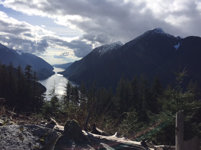
- IMG_4804.JPG (103.62 KiB) Viewed 5008 times
Here’s my son in front of about half of Stave Lake…

- IMG_4816.JPG (167.21 KiB) Viewed 5008 times
…and a view from the end of the road I took with Mt. Robie Reid (2095m/6874 ft) in the background. There was a bit of a wash out, and the road ended only about 500 meters further up, so I wussed and called it a day. I’m not geared for digging the truck out, really. I was hoping to climb to snow as I had 2 Mexican and 1 German exchange students with me, but we fell way short! the snow's another 1000' above us at the top of this mountain.
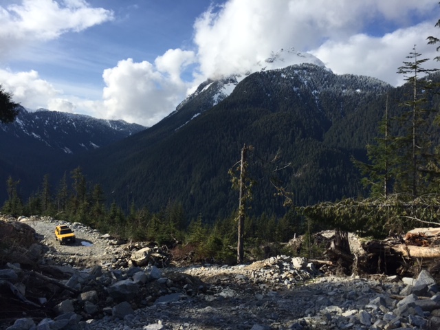
- IMG_4813.JPG (129.93 KiB) Viewed 5008 times
Byron
Re: Bike rides
Posted: 03 May 2016 12:35
by bertvorgon
I'd like to know how to get up that road Byron, be nice to head up there just for the view and burn some smokies over a small fire.
Re: Bike rides
Posted: 03 May 2016 14:02
by KiKiIchiBan
Looks beautiful
Re: Bike rides
Posted: 03 May 2016 14:57
by RMS
there we go, a perfect 510club expedition ...what about Saturday the 14th
Re: Bike rides
Posted: 03 May 2016 22:32
by Byron510
From where you turn off Dewdney Trunk Rd at the Stave Falls dam, it's only about an hour to this trail head where I took this photo. I'd totally be into taking a drive in there with you all for a lunch, sounds like a great plan.
Does Robyn's date work for you? Sounds like a good starting point to me.
Byron
Re: Bike rides
Posted: 11 Jun 2017 09:00
by bertvorgon
Last weekend, Matt and I decided to flee the “big smoke” and check out the East Harrison Forest service road and see if we could get through to Boston Bar.
The road starts just to the east of Harrison proper, winds along the lake passing some very expensive homes, then turns to gravel after the entrance to a small Provincial campsite.
Wow is the road rough, it gets a TON of traffic by the weekend hoards, so it is blasted down to the base road fill, with a horrible washboard on all the hills.
As we went past a few of the campsites that literally are on the edge of the lake, and, a few others next to creeks flowing in, I have never been so disgusted with this group of people. I thought it was bad out the Chilliwack Lake way. The amount of garbage and crap left was beyond description. I do not understand that. This again pointed out that ANYTHING within the 100 mile blast radius of Vancouver is just violated by the red neck, party crowd. Why our poor planet is doomed.
At around the 50 Km mark we started to see we were away from the worst of the camping crowd, the Service road starting to do some serious climbing for elevation. As the valley headed east and up we were amazed at how many beautiful waterfalls there are, all in full flow with the spring snow melt. Speaking of snow, there is still tons up high, as were soon to find out.
We stopped at one very large waterfall along the road, and incredible volume of water flowing over it. We hiked down through the trees on a small trail, where we were right beside the plunge of water. Matt set up his tripod and took a stunning panorama shot that I want to get enlarged and framed. That boy is good!
The road we could see had had some serious washouts and was almost 4 x 4 time on a couple of climbs as it was so loose and rocky.
Around noon we went up an old side road to build a small fire and look out over the valley, enjoying our roasted smokie’s in the afternoon sun.
In another half hour of climbing, we could see we were getting close to the snow line so of course started to wonder if the road would be blocked. Sure enough, at the 3,900 foot level, we started to encounter snow on the road, finally being stopped almost at the top of the pass…so close yet so far!
We got out and walked a few 100 feet up the road, on the blinding snow, resigned to the fact that there was no way to go any further. It will be another 2-3 weeks before this will be clear, as at the point we turned around there was still 2-3 feet of snow. The Hurley Pass was just bulldozed through last week, to open it up, with 5 feet of snow still there at 4,900 feet.
Retracing our steps had us back to Harrison Lake in a couple of hours, where, to my disgust again, three sites that we watched people packing up at, had left TONS of garbage!!!! I was so mad and it still bothers me.
I think later in the fall, we will retry this trip, maybe pop up to the Nahatlatch and camp out over night……I wonder how it is doing?
Keith Law
June 11, 2017
Re: Bike rides
Posted: 11 Jun 2017 09:02
by bertvorgon
More
Re: Bike rides
Posted: 11 Jun 2017 09:03
by bertvorgon
last
Re: Bike rides
Posted: 11 Jun 2017 12:07
by KiKiIchiBan
Stunning, wish I was still in B.C
Re: Bike rides
Posted: 12 Jun 2017 00:30
by Byron510
I did the road from Nahatlatch dropping back into Harrison last year, the road was great, no 4wd needed. I put the truck in low range one to decend one hill just so I wouldn't have to use the brakes.
Great country. I crossed the pass in August, no snow to be seen anywhere near the road last year. But this year we really got dumped on so this doesn't surprise me.
It's a nice drive, hope you get over next try.
Byron
Re: Bike rides
Posted: 12 Jun 2017 22:01
by gooned
Done that route heading the other way twice now and the exact trip you just did into the snow once a few years back too...only I was with a group of trucks that were stopping to pack garbage out, I loaded out most of an abandoned camper remains in Yeller.
Great views all along there and also up at the rebuilt Nahatlatch tower. Apparently there is a mine high up past the tower, don't know if you'd have any info on that area?
Re: Bike rides
Posted: 13 Jun 2017 07:01
by bertvorgon
MINE...did you say....MINE......?
Time to get out the lights and boots and go find it. Can you pin point it on a map for me? Then, I can try to see if I can find it in the records.
Not familiar with the "tower" as I have never been in that area. It always seemed too busy way back when the opened the Nahatlach up and back in the 70's you had to take an aerial car ferry over to Boston Bar. so on a Friday night the line up could be a major wait to get across the river.
Re: Bike rides
Posted: 13 Jun 2017 21:22
by gooned
Hmm, I'll post a link to an earlier trip, I can't find the more recent one right now...
http://www.overlandcanada.com/forum/sho ... n-Harrison
Unfortunately I only heard rumor of a mine if you carry on past the fire lookout, so I don't know where to out it on a map.
Found our more recent trip...
http://www.overlandcanada.com/forum/sho ... #post45452
Re: Bike rides
Posted: 14 Jun 2017 07:12
by bertvorgon
Morning Jason,
This is all I could find for up the Nahatlatch, at least in the mining records. I"m sure like all areas there has been a ton of prospecting up all these valleys, but this one had some good sampling and trenching done. A team went up there in the late 90's to re-survey things, but in their report, they could not find the actual "KEEFER" showing, likely really grown over now after 60 years. Makes sense they were looking at nickel as the major, as there was that nickel mine outside of Yale for a lot of years. It also makes sense that they sent the sample to Sudbury, Ontario, as that would have been INCO, Canada's largest nickel mine, so they would have been very familiar with assaying for low concentrations of platinum, as that is a big byproduct of nickel mining.
PRODUCT: NICKEL
Associated minerals or products
- Copper, cobalt? platinum,
. .
PROVINCE OR PROVINCE Of British Columbia
TERRITORY
Mineral Policy Sector, Department of Energy, Mines and Resources, Ottawa
508787 * _
NAME OF PROPERTY KEEFERS
OBJECT LOCATE-D
UNCERTAINTY approx. at. 50°00'20" Long. 121'33 '30"
F
Mining Division New Westminster District Yale
County Township or Parish
~ot Concession or Range
~ot Concession ou rang
Sec TP. R.
Sect. Ct. R.
OWNER OR
N.T.S. AREA 92 I/4
HISTORY OF EXPLORATION AND DEVELOPMENT
This property is located at about the 1,200 foot elevation
on the north side of Nahatlatch River, some 14 miles southwest
of Keefers, and 17 miles south of Lytton.
The showings were discovered and staked by D. Pride in
1954; some open.cutting was done at that time. Northwest
Ventures Ltd. optioned the 23 claim property in 1955 and some
surface work and diamond drilling was reported. A representative
sample, sent by the company to Sudbury for assay, is
reported to have returned values of 1.42% copper, 2.24% nickel,
0.15% cobalt, and 0.11 ounce platinum and 0.023 ounce palladium
Re: Bike rides
Posted: 14 Jun 2017 07:22
by bertvorgon
I did find this also, very interesting, in looking for gold they found silica and talc. A small shaft can be found there, pictures are on the Net, Type in GISBY MINE.
http://minfile.gov.bc.ca/Summary.aspx?m ... =092HNW002